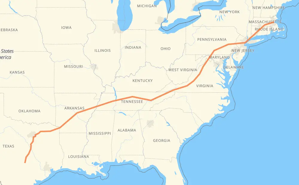
Distance between Austin TX and Boston MA
The distance from Austin to Boston is 1,949 miles by road including 1,921 miles on motorways. Road takes approximately 30 hours and 41 minutes and goes through Round Rock, Waco, Dallas, Mesquite, Garland, Little Rock and Memphis.
| Shortest distance by air | 1,694 mi ✈️ |
| Car route length | 1,948.6 mi 🚗 |
| Driving time | 30 h 41 min |
| Fuel amount | 66.3 gal |
| Fuel cost | 260.5 USD |
| Point | Distance | Time | Fuel | |
| Austin | 0 mi | 00 min | 0.0 gal | |
|
I 35 19 mi, 18 min
|
||||
| Round Rock | 19 mi | 18 min | 0.6 gal | |
|
I 35 80 mi, 1 h 13 min
|
||||
| Waco | 100 mi | 1 h 31 min | 3.2 gal | |
|
I 35 I 35E 94 mi, 1 h 32 min
|
||||
| Dallas | 194 mi | 3 h 03 min | 6.1 gal | |
|
I 35E I 635 24 mi, 23 min
|
||||
| Mesquite | 218 mi | 3 h 27 min | 7.3 gal | |
|
I 635 6 mi, 05 min
|
||||
| Garland | 224 mi | 3 h 33 min | 7.5 gal | |
|
I 30 4 mi, 04 min
|
||||
| Dallas | 228 mi | 3 h 37 min | 7.7 gal | |
|
I 30 294 mi, 4 h 47 min
|
||||
| Little Rock | 522 mi | 8 h 25 min | 17.5 gal | |
|
I 30 I 40 147 mi, 2 h 16 min
|
||||
| Memphis | 669 mi | 10 h 41 min | 22.4 gal | |
|
I 40 68 mi, 1 h 01 min
|
||||
| Jackson | 736 mi | 11 h 43 min | 24.7 gal | |
|
I 40 134 mi, 2 h 01 min
|
||||
| Nashville | 870 mi | 13 h 44 min | 29.5 gal | |
|
I 40 178 mi, 2 h 39 min
|
||||
| Knoxville | 1,048 mi | 16 h 23 min | 35.6 gal | |
|
I 40 I 81 94 mi, 1 h 25 min
|
||||
| Kingsport | 1,142 mi | 17 h 49 min | 38.6 gal | |
|
I 81 260 mi, 3 h 53 min
|
||||
| Harrisonburg | 1,402 mi | 21 h 42 min | 47.6 gal | |
|
I 81 111 mi, 1 h 39 min
|
||||
| Hagerstown | 1,513 mi | 23 h 21 min | 51.4 gal | |
|
I 81 73 mi, 1 h 08 min
|
||||
| Harrisburg | 1,586 mi | 24 h 29 min | 53.9 gal | |
|
I 81 I 78 79 mi, 1 h 17 min
|
||||
| Allentown | 1,665 mi | 25 h 47 min | 56.6 gal | |
|
I 78 8 mi, 07 min
|
||||
| Bethlehem | 1,673 mi | 25 h 55 min | 56.9 gal | |
|
I 78 70 mi, 1 h 05 min
|
||||
| Newark | 1,743 mi | 27 h 01 min | 59.1 gal | |
|
I 78 I 95 21 mi, 24 min
|
||||
| New York | 1,764 mi | 27 h 25 min | 59.8 gal | |
|
US 1 I 95 25 mi, 27 min
|
||||
| Stamford | 1,788 mi | 27 h 53 min | 60.8 gal | |
|
I 95 22 mi, 24 min
|
||||
| Bridgeport | 1,811 mi | 28 h 17 min | 61.5 gal | |
|
CT 8 CT 15 14 mi, 15 min
|
||||
| New Haven | 1,825 mi | 28 h 33 min | 61.9 gal | |
|
CT 15 37 mi, 43 min
|
||||
| Hartford | 1,862 mi | 29 h 16 min | 63.3 gal | |
|
US 5 I 90 101 mi, 1 h 39 min
|
||||
| Boston | 1,963 mi | 30 h 56 min | 66.5 gal | |
Hotels of Boston
Frequently Asked Questions
How much does it cost to drive from Austin to Boston?
Fuel cost: 260.5 USD
This fuel cost is calculated as: (Route length 1,948.6 mi) / (Fuel consumption 29.4 mpg) * (Fuel price 3.93 USD / gal)
You can adjust fuel consumption and fuel price here.
How long is a car ride from Austin to Boston?
Driving time: 30 h 41 min
This time is calculated for driving at the maximum permitted speed, taking into account traffic rules restrictions.
- 1,051 mi with a maximum speed 68 mph = 15 h 27 min
- 406 mi with a maximum speed 65 mph = 6 h 14 min
- 129 mi with a maximum speed 62 mph = 2 h 4 min
- 52 mi with a maximum speed 60 mph = 51 min
- 1 mi with a maximum speed 56 mph = 1 min
- 119 mi with a maximum speed 55 mph = 2 h 9 min
- 187 mi with a maximum speed 50 mph = 3 h 45 min
- 2 mi with a maximum speed 40 mph = 2 min
- 1 mi with a maximum speed 25 mph = 1 min
The calculated driving time does not take into account intermediate stops and traffic jams.
How far is Austin to Boston by land?
The distance between Austin and Boston is 1,948.6 mi by road including 1,920.7 mi on motorways.
Precise satellite coordinates of highways were used for this calculation. The start and finish points are the centers of Austin and Boston respectively.
How far is Austin to Boston by plane?
The shortest distance (air line, as the crow flies) between Austin and Boston is 1,694.5 mi.
This distance is calculated using the Haversine formula as a great-circle distance between two points on the surface of a sphere. The start and finish points are the centers of Austin and Boston respectively. Actual distance between airports may be different.
How many hours is Austin from Boston by plane?
Boeing 737 airliner needs 3 h 24 min to cover the distance of 1,694 mi at a cruising speed of 497 mph.
Small plane "Cessna 172" needs 12 h 23 min to flight this distance at average speed of 136 mph.
This time is approximate and do not take into account takeoff and landing times, airport location and other real world factors.
How long is a helicopter ride from Austin to Boston?
Fast helicopter "Eurocopter AS350" or "Hughes OH-6 Cayuse" need 11 h 21 min to cover the distance of 1,694 mi at a cruising speed of 149 mph.
Popular "Robinson R44" needs 12 h 59 min to flight this distance at average speed of 130 mph.
This time is approximate and do not take into account takeoff and landing times, aerodrome location and other real world factors.
What city is halfway between Austin and Boston?
The halfway point between Austin and Boston is Dorton. It is located about 10 mi from the exact midpoint by road.
The distance from Dorton to Austin is 985 mi and driving will take about 15 h 25 min. The road between Dorton and Boston has length 964 mi and will take approximately 15 h 15 min.
The other cities located close to halfway point:
Where is Austin in relation to Boston?
Austin is located 1,694 mi south-west of Boston.
Austin has geographic coordinates: latitude 30.27113, longitude -97.7437.
Boston has geographic coordinates: latitude 42.36048, longitude -71.05957.
Which highway goes from Austin to Boston?
The route from Austin to Boston follows I 40, I 81, I 30, I 35, I 78, US 67.
Other minor sections pass along the road:
- I 35E: 61 mi
- US 22: 57 mi
- I 90: 55 mi
- I 95: 53 mi
- CT 15: 49 mi
- I 84: 40 mi
- US 77: 35 mi
- I 64: 30 mi
- US 11: 24 mi
- US 70: 21 mi
- US 58: 18 mi
- I 75: 16 mi
- US 5: 15 mi
- I 20: 12 mi
- US 1: 11 mi
- NJTP: 11 mi
- I 440: 10 mi
- I 635: 9 mi
- US 52: 9 mi
- I 77: 8 mi
- VA 100: 7 mi
- US 412: 7 mi
- US 220: 6 mi
- SR 56: 6 mi
- PA 309: 6 mi
- I-30: 5 mi
- US-70: 5 mi
- CT 8: 5 mi
- US 190: 5 mi
- US 9: 4 mi
- US 290: 4 mi
- CT 25: 3 mi
- US 46: 3 mi
- US 6: 2 mi
- US-67: 2 mi
- I 55: 2 mi
- I 65: 2 mi
- US 59: 2 mi
- US 322: 2 mi
- I 24: 2 mi
- SR 299: 2 mi
- US 270: 1 mi
- NJ 173: 1 mi
- MP: 1 mi