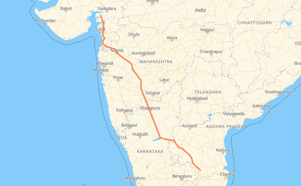
The distance from Chaudepalle to Jambusar is 839 miles by road. Road takes approximately 16 hours and 21 minutes and goes through Anantapur, Ballari, Vijayapura, Ahmadnagar, Nashik and Valsad.
You can adjust fuel consumption and fuel price here.
How long is a car ride from Chaudepalle to Jambusar?
Driving time:
16 h 21 min
This time is calculated for driving at the maximum permitted speed, taking into account traffic rules restrictions.
278 mi with a maximum speed 56 mph = 4 h 58 min
556 mi with a maximum speed 50 mph = 11 h 10 min
6 mi with a maximum speed 31 mph = 12 min
The calculated driving time does not take into account intermediate stops and traffic jams.
How far is Chaudepalle to Jambusar by land?
The distance between Chaudepalle and Jambusar is 838.9 mi by road.
Precise satellite coordinates of highways were used for this calculation. The start and finish points are the centers of Chaudepalle and Jambusar respectively.
How far is Chaudepalle to Jambusar by plane?
The shortest distance (air line, as the crow flies) between Chaudepalle and Jambusar is 710.2 mi.
This distance is calculated using the Haversine formula as a great-circle distance between two points on the surface of a sphere. The start and finish points are the centers of Chaudepalle and Jambusar respectively. Actual distance between airports may be different.
How many hours is Chaudepalle from Jambusar by plane?
Boeing 737 airliner needs 1 h 25 min to cover the distance of 710 mi at a cruising speed of 497 mph.
Small plane "Cessna 172" needs 5 h 11 min to flight this distance at average speed of 136 mph.
This time is approximate and do not take into account takeoff and landing times, airport location and other real world factors.
How long is a helicopter ride from Chaudepalle to Jambusar?
Fast helicopter "Eurocopter AS350" or "Hughes OH-6 Cayuse" need 4 h 45 min to cover the distance of 710 mi at a cruising speed of 149 mph.
Popular "Robinson R44" needs 5 h 26 min to flight this distance at average speed of 130 mph.
This time is approximate and do not take into account takeoff and landing times, aerodrome location and other real world factors.
What city is halfway between Chaudepalle and Jambusar?
The halfway point between Chaudepalle and Jambusar is Pandharpur. It is located about 1 mi from the exact midpoint by road.
The distance from Pandharpur to Chaudepalle is 419 mi and driving will take about 8 h 15 min. The road between Pandharpur and Jambusar has length 420 mi and will take approximately 8 h 5 min.
The other cities located close to halfway point:
Mangalwedha is in 404 mi from Chaudepalle and 435 mi from Jambusar
Karkamb is in 437 mi from Chaudepalle and 401 mi from Jambusar
Tembhurni is in 449 mi from Chaudepalle and 390 mi from Jambusar
Where is Chaudepalle in relation to Jambusar?
Chaudepalle is located 710 mi south-east of Jambusar.
Chaudepalle has geographic coordinates: latitude 13.43361, longitude 78.69036.
Jambusar has geographic coordinates: latitude 22.05099, longitude 72.80627.
Which highway goes from Chaudepalle to Jambusar?
The route from Chaudepalle to Jambusar follows NH561A, NH42, NH50, NH48, NH848.