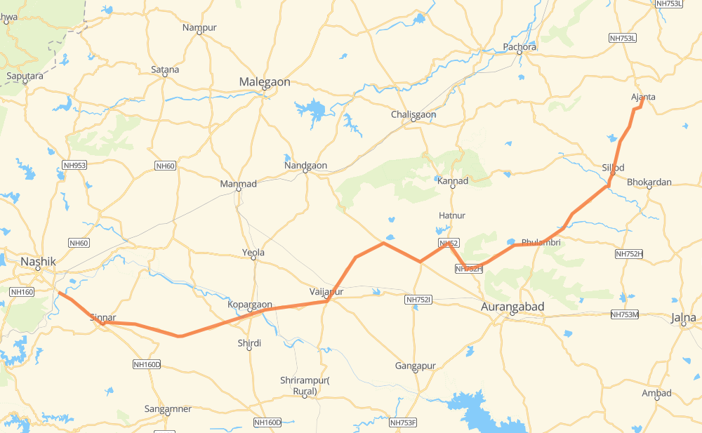
Distance between Deolali and Ajanta
The distance from Deolali to Ajanta is 163 miles by road. Road takes approximately 3 hours and 9 minutes and goes through Sinnar, Kopargaon, Vaijapur and Sillod.
| Shortest distance by air | 130 mi ✈️ |
| Car route length | 162.8 mi 🚗 |
| Driving time | 3 h 9 min |
| Fuel amount | 5.5 gal |
| Fuel cost | 21.7 USD |
| Point | Distance | Time | Fuel | |
| Deolali | 0 mi | 00 min | 0.0 gal | |
|
NH60 4 mi, 04 min
|
||||
| Deolali Cantonment | 4 mi | 04 min | 0.0 gal | |
|
NH60 10 mi, 11 min
|
||||
| Sinnar | 14 mi | 16 min | 0.3 gal | |
|
NH160 13 mi, 15 min
|
||||
| Vavi | 27 mi | 32 min | 0.7 gal | |
|
NH160 12 mi, 14 min
|
||||
| Pohegaon Khurd | 39 mi | 46 min | 1.3 gal | |
|
NH160 NH160B 5 mi, 05 min
|
||||
| Kopargaon | 44 mi | 52 min | 1.5 gal | |
|
NH160B 4 mi, 04 min
|
||||
| Samvatsar | 48 mi | 57 min | 1.5 gal | |
|
NH752I 14 mi, 16 min
|
||||
| Vaijapur | 62 mi | 1 h 13 min | 2.0 gal | |
|
NH752I NH752H 83 mi, 1 h 34 min
|
||||
| Sillod | 145 mi | 2 h 48 min | 4.8 gal | |
|
NH753F 17 mi, 20 min
|
||||
| Ajanta | 163 mi | 3 h 09 min | 5.1 gal | |
Hotels of Ajanta
Frequently Asked Questions
How much does it cost to drive from Deolali to Ajanta?
Fuel cost: 21.7 USD
This fuel cost is calculated as: (Route length 162.8 mi) / (Fuel consumption 29.4 mpg) * (Fuel price 3.93 USD / gal)
You can adjust fuel consumption and fuel price here.
How long is a car ride from Deolali to Ajanta?
Driving time: 3 h 9 min
This time is calculated for driving at the maximum permitted speed, taking into account traffic rules restrictions.
- 52 mi with a maximum speed 56 mph = 55 min
- 111 mi with a maximum speed 50 mph = 2 h 13 min
The calculated driving time does not take into account intermediate stops and traffic jams.
How far is Deolali to Ajanta by land?
The distance between Deolali and Ajanta is 162.8 mi by road.
Precise satellite coordinates of highways were used for this calculation. The start and finish points are the centers of Deolali and Ajanta respectively.
How far is Deolali to Ajanta by plane?
The shortest distance (air line, as the crow flies) between Deolali and Ajanta is 129.9 mi.
This distance is calculated using the Haversine formula as a great-circle distance between two points on the surface of a sphere. The start and finish points are the centers of Deolali and Ajanta respectively. Actual distance between airports may be different.
How many hours is Deolali from Ajanta by plane?
Boeing 737 airliner needs 15 min to cover the distance of 130 mi at a cruising speed of 497 mph.
Small plane "Cessna 172" needs 57 min to flight this distance at average speed of 136 mph.
This time is approximate and do not take into account takeoff and landing times, airport location and other real world factors.
How long is a helicopter ride from Deolali to Ajanta?
Fast helicopter "Eurocopter AS350" or "Hughes OH-6 Cayuse" need 52 min to cover the distance of 130 mi at a cruising speed of 149 mph.
Popular "Robinson R44" needs 59 min to flight this distance at average speed of 130 mph.
This time is approximate and do not take into account takeoff and landing times, aerodrome location and other real world factors.
What city is halfway between Deolali and Ajanta?
The halfway point between Deolali and Ajanta is Galle Borgaon. It is located about 17 mi from the exact midpoint by road.
The distance from Galle Borgaon to Deolali is 98 mi and driving will take about 1 h 53 min. The road between Galle Borgaon and Ajanta has length 65 mi and will take approximately 1 h 16 min.
The other cities located close to halfway point:
Where is Deolali in relation to Ajanta?
Deolali is located 130 mi south-west of Ajanta.
Deolali has geographic coordinates: latitude 19.9378, longitude 73.85648.
Ajanta has geographic coordinates: latitude 20.53252, longitude 75.75136.