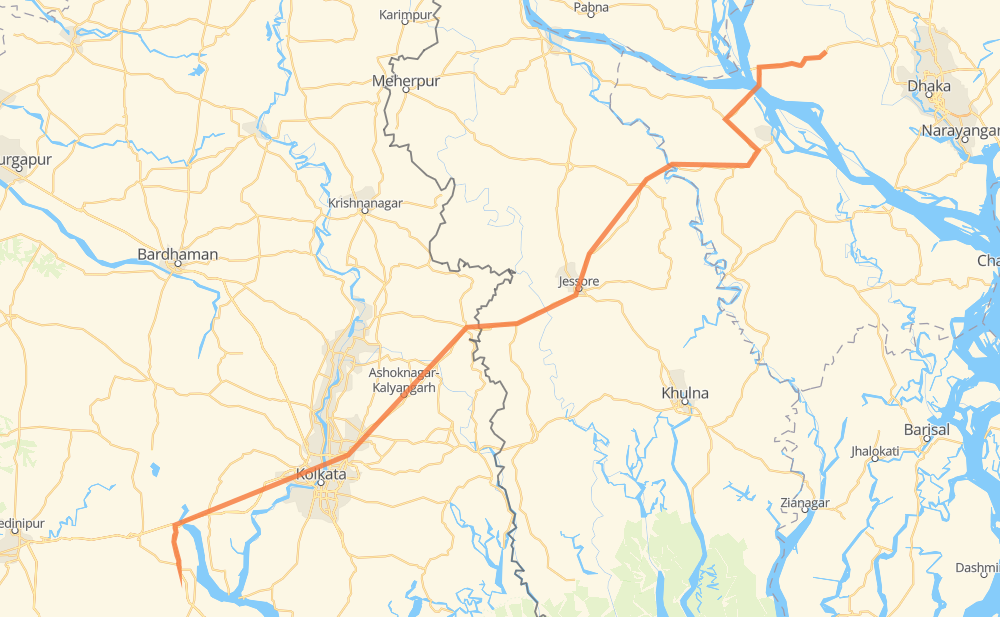
Distance between Kolaghat and Jaigir
The distance from Kolaghat to Jaigir is 227 miles by road. Road takes approximately 4 hours and 27 minutes and goes through Panskura, Tamluk, Uluberiya, Dunlop, Pratapgarh, Barasat and Habra.
| Shortest distance by air | 171 mi ✈️ |
| Car route length | 226.8 mi 🚗 |
| Driving time | 4 h 27 min |
| Fuel amount | 7.7 gal |
| Fuel cost | 30.3 USD |
| Point | Distance | Time | Fuel | |
| Kolaghat | 0 mi | 00 min | 0.0 gal | |
|
NH116 NH16 34 mi, 38 min
|
||||
| Uluberiya | 34 mi | 38 min | 1.1 gal | |
|
NH16 24 mi, 26 min
|
||||
| Dunlop | 58 mi | 1 h 05 min | 1.9 gal | |
|
NH12 4 mi, 04 min
|
||||
| Pratapgarh | 62 mi | 1 h 09 min | 2.1 gal | |
|
NH12 10 mi, 11 min
|
||||
| Barasat | 72 mi | 1 h 21 min | 2.3 gal | |
|
NH112 25 mi, 28 min
|
||||
| Bangaon | 98 mi | 1 h 49 min | 3.1 gal | |
|
NH112 9 mi, 11 min
|
||||
| Benapole | 107 mi | 2 h 01 min | 3.6 gal | |
|
N706 13 mi, 15 min
|
||||
| jhikargacha | 120 mi | 2 h 16 min | 3.8 gal | |
|
N706 14 mi, 16 min
|
||||
| Jessore | 134 mi | 2 h 33 min | 4.3 gal | |
|
N702 N7 93 mi, 1 h 53 min
|
||||
| Jaigir | 227 mi | 4 h 27 min | 7.7 gal | |
Frequently Asked Questions
How much does it cost to drive from Kolaghat to Jaigir?
Fuel cost: 30.3 USD
This fuel cost is calculated as: (Route length 226.8 mi) / (Fuel consumption 29.4 mpg) * (Fuel price 3.93 USD / gal)
You can adjust fuel consumption and fuel price here.
How long is a car ride from Kolaghat to Jaigir?
Driving time: 4 h 27 min
This time is calculated for driving at the maximum permitted speed, taking into account traffic rules restrictions.
- 107 mi with a maximum speed 56 mph = 1 h 54 min
- 114 mi with a maximum speed 50 mph = 2 h 17 min
- 2 mi with a maximum speed 37 mph = 3 min
- 1 mi with a maximum speed 31 mph = 1 min
- 2 mi with a maximum speed 12 mph = 9 min
The calculated driving time does not take into account intermediate stops and traffic jams.
How far is Kolaghat to Jaigir by land?
The distance between Kolaghat and Jaigir is 226.8 mi by road.
Precise satellite coordinates of highways were used for this calculation. The start and finish points are the centers of Kolaghat and Jaigir respectively.
How far is Kolaghat to Jaigir by plane?
The shortest distance (air line, as the crow flies) between Kolaghat and Jaigir is 170.9 mi.
This distance is calculated using the Haversine formula as a great-circle distance between two points on the surface of a sphere. The start and finish points are the centers of Kolaghat and Jaigir respectively. Actual distance between airports may be different.
How many hours is Kolaghat from Jaigir by plane?
Boeing 737 airliner needs 20 min to cover the distance of 171 mi at a cruising speed of 497 mph.
Small plane "Cessna 172" needs 1 h 15 min to flight this distance at average speed of 136 mph.
This time is approximate and do not take into account takeoff and landing times, airport location and other real world factors.
How long is a helicopter ride from Kolaghat to Jaigir?
Fast helicopter "Eurocopter AS350" or "Hughes OH-6 Cayuse" need 1 h 8 min to cover the distance of 171 mi at a cruising speed of 149 mph.
Popular "Robinson R44" needs 1 h 18 min to flight this distance at average speed of 130 mph.
This time is approximate and do not take into account takeoff and landing times, aerodrome location and other real world factors.
What city is halfway between Kolaghat and Jaigir?
The halfway point between Kolaghat and Jaigir is Benapole. It is located about 7 mi from the exact midpoint by road.
The distance from Benapole to Kolaghat is 107 mi and driving will take about 2 h 1 min. The road between Benapole and Jaigir has length 120 mi and will take approximately 2 h 26 min.
The other cities located close to halfway point:
Where is Kolaghat in relation to Jaigir?
Kolaghat is located 171 mi south-west of Jaigir.
Kolaghat has geographic coordinates: latitude 22.4302, longitude 87.86239.
Jaigir has geographic coordinates: latitude 23.89521, longitude 90.02575.