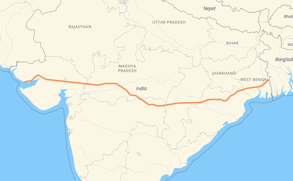
The distance from Mandvi to Gaighata is 1,491 miles by road. Road takes approximately 29 hours and 46 minutes and goes through Gandhidham, Indore, Durg, Bhilai, Raipur and Kharagpur.
You can adjust fuel consumption and fuel price here.
How long is a car ride from Mandvi to Gaighata?
Driving time:
29 h 46 min
This time is calculated for driving at the maximum permitted speed, taking into account traffic rules restrictions.
672 mi with a maximum speed 56 mph = 12 h
713 mi with a maximum speed 50 mph = 14 h 20 min
122 mi with a maximum speed 37 mph = 3 h 15 min
4 mi with a maximum speed 31 mph = 7 min
1 mi with a maximum speed 25 mph = 1 min
The calculated driving time does not take into account intermediate stops and traffic jams.
How far is Mandvi to Gaighata by land?
The distance between Mandvi and Gaighata is 1,491.3 mi by road.
Precise satellite coordinates of highways were used for this calculation. The start and finish points are the centers of Mandvi and Gaighata respectively.
How far is Mandvi to Gaighata by plane?
The shortest distance (air line, as the crow flies) between Mandvi and Gaighata is 1,237.2 mi.
This distance is calculated using the Haversine formula as a great-circle distance between two points on the surface of a sphere. The start and finish points are the centers of Mandvi and Gaighata respectively. Actual distance between airports may be different.
How many hours is Mandvi from Gaighata by plane?
Boeing 737 airliner needs 2 h 29 min to cover the distance of 1,237 mi at a cruising speed of 497 mph.
Small plane "Cessna 172" needs 9 h 3 min to flight this distance at average speed of 136 mph.
This time is approximate and do not take into account takeoff and landing times, airport location and other real world factors.
How long is a helicopter ride from Mandvi to Gaighata?
Fast helicopter "Eurocopter AS350" or "Hughes OH-6 Cayuse" need 8 h 17 min to cover the distance of 1,237 mi at a cruising speed of 149 mph.
Popular "Robinson R44" needs 9 h 28 min to flight this distance at average speed of 130 mph.
This time is approximate and do not take into account takeoff and landing times, aerodrome location and other real world factors.
What city is halfway between Mandvi and Gaighata?
The halfway point between Mandvi and Gaighata is Umari. It is located about 4 mi from the exact midpoint by road.
The distance from Umari to Mandvi is 750 mi and driving will take about 15 h 10 min. The road between Umari and Gaighata has length 742 mi and will take approximately 14 h 35 min.
The other cities located close to halfway point:
Saoner is in 757 mi from Mandvi and 734 mi from Gaighata
Seoni is in 734 mi from Mandvi and 758 mi from Gaighata
Malegaon is in 761 mi from Mandvi and 731 mi from Gaighata
Where is Mandvi in relation to Gaighata?
Mandvi is located 1,237 mi west of Gaighata.
Mandvi has geographic coordinates: latitude 22.83103, longitude 69.35002.
Gaighata has geographic coordinates: latitude 22.98567, longitude 88.7983.
Which highway goes from Mandvi to Gaighata?
The route from Mandvi to Gaighata follows NH47, NH53, NH49, NH947, SH6, SH7, NH16.