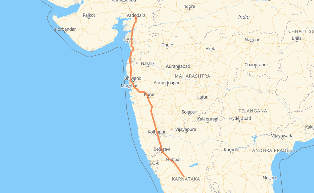
The distance from Ranebennur to Karachiya is 670 miles by road. Road takes approximately 13 hours and 21 minutes and goes through Panvel, Thane, Valsad and Vadodara.
You can adjust fuel consumption and fuel price here.
How long is a car ride from Ranebennur to Karachiya?
Driving time:
13 h 21 min
This time is calculated for driving at the maximum permitted speed, taking into account traffic rules restrictions.
170 mi with a maximum speed 56 mph = 3 h 2 min
86 mi with a maximum speed 53 mph = 1 h 38 min
418 mi with a maximum speed 50 mph = 8 h 25 min
1 mi with a maximum speed 43 mph = 1 min
5 mi with a maximum speed 37 mph = 8 min
2 mi with a maximum speed 34 mph = 3 min
1 mi with a maximum speed 31 mph = 1 min
The calculated driving time does not take into account intermediate stops and traffic jams.
How far is Ranebennur to Karachiya by land?
The distance between Ranebennur and Karachiya is 670.5 mi by road.
Precise satellite coordinates of highways were used for this calculation. The start and finish points are the centers of Ranebennur and Karachiya respectively.
How far is Ranebennur to Karachiya by plane?
The shortest distance (air line, as the crow flies) between Ranebennur and Karachiya is 561.1 mi.
This distance is calculated using the Haversine formula as a great-circle distance between two points on the surface of a sphere. The start and finish points are the centers of Ranebennur and Karachiya respectively. Actual distance between airports may be different.
How many hours is Ranebennur from Karachiya by plane?
Boeing 737 airliner needs 1 h 7 min to cover the distance of 561 mi at a cruising speed of 497 mph.
Small plane "Cessna 172" needs 4 h 6 min to flight this distance at average speed of 136 mph.
This time is approximate and do not take into account takeoff and landing times, airport location and other real world factors.
How long is a helicopter ride from Ranebennur to Karachiya?
Fast helicopter "Eurocopter AS350" or "Hughes OH-6 Cayuse" need 3 h 45 min to cover the distance of 561 mi at a cruising speed of 149 mph.
Popular "Robinson R44" needs 4 h 18 min to flight this distance at average speed of 130 mph.
This time is approximate and do not take into account takeoff and landing times, aerodrome location and other real world factors.
What city is halfway between Ranebennur and Karachiya?
The halfway point between Ranebennur and Karachiya is Bavdhan Budruk. It is located about 1 mi from the exact midpoint by road.
The distance from Bavdhan Budruk to Ranebennur is 335 mi and driving will take about 6 h 36 min. The road between Bavdhan Budruk and Karachiya has length 336 mi and will take approximately 6 h 44 min.
The other cities located close to halfway point:
Dhayari is in 326 mi from Ranebennur and 345 mi from Karachiya
Talegaon is in 350 mi from Ranebennur and 321 mi from Karachiya
Nasrapur is in 316 mi from Ranebennur and 355 mi from Karachiya
Where is Ranebennur in relation to Karachiya?
Ranebennur is located 561 mi south-east of Karachiya.
Ranebennur has geographic coordinates: latitude 14.61658, longitude 75.63415.
Karachiya has geographic coordinates: latitude 22.37823, longitude 73.13234.
Which highway goes from Ranebennur to Karachiya?
The route from Ranebennur to Karachiya follows NH48.