Distance between Table and Bus
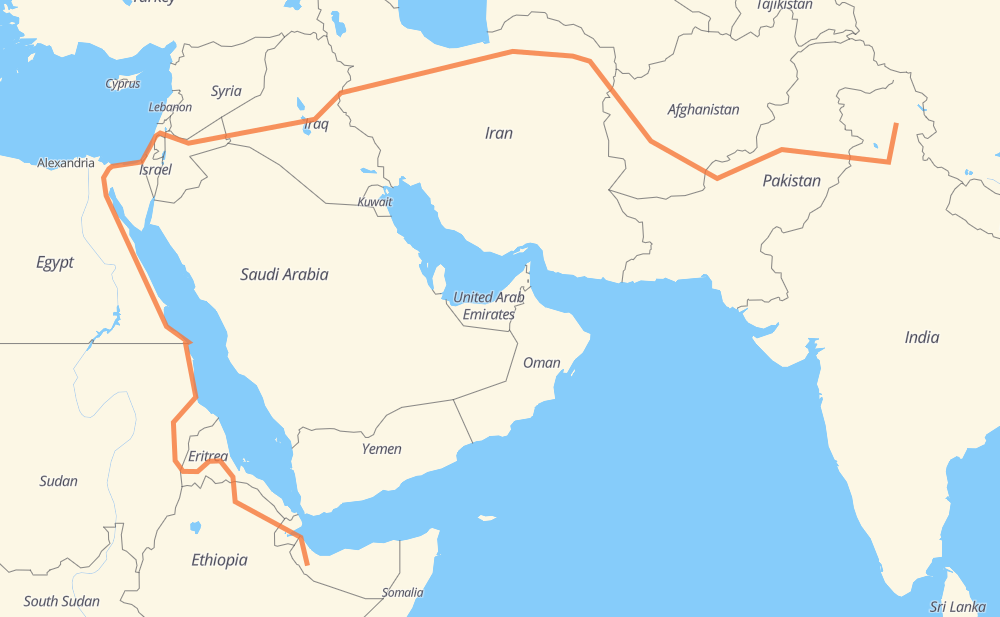
The distance from Table to Bus is 5,947 miles by road including 797 miles on motorways. Road takes approximately 113 hours and 40 minutes and goes through Amritsar, Pir Mahal, Kamalia, Atharan Hazari, Bhakkar, Zhob and Chaman.
| Shortest distance by air | 2,669 mi ✈️ |
| Car route length | 5,947.1 mi 🚗 |
| Driving time | 113 h 40 min |
| Fuel amount | 202.3 gal |
| Fuel cost | 795 USD |
| Point | Distance | Time | Fuel | |
| Kargyak | 0 mi | 00 min | 0.0 gal | |
|
NH3 404 mi, 9 h 19 min
|
||||
| Amritsar | 404 mi | 9 h 19 min | 13.6 gal | |
|
M-3 213 mi, 3 h 42 min
|
||||
| Atharan Hazari | 616 mi | 13 h 02 min | 20.2 gal | |
|
50 mi, 1 h 00 min
|
||||
| Bhakkar | 666 mi | 14 h 02 min | 22.6 gal | |
|
N-50 151 mi, 2 h 49 min
|
||||
| Zhob | 817 mi | 16 h 52 min | 27.4 gal | |
|
N-50 239 mi, 4 h 34 min
|
||||
| Chaman | 1,056 mi | 21 h 27 min | 35.7 gal | |
|
N-25 NH37 73 mi, 1 h 20 min
|
||||
| Kandahar | 1,130 mi | 22 h 47 min | 38.2 gal | |
|
NH0101 NH0102 350 mi, 6 h 17 min
|
||||
| Herat | 1,480 mi | 29 h 05 min | 50.2 gal | |
|
NH0102 97 270 mi, 5 h 07 min
|
||||
| Neyshabur | 1,750 mi | 34 h 12 min | 59.5 gal | |
|
44 70 mi, 1 h 16 min
|
||||
| Sabzevar | 1,820 mi | 35 h 28 min | 61.8 gal | |
|
44 402 mi, 7 h 22 min
|
||||
| Tehran | 2,222 mi | 42 h 51 min | 75.3 gal | |
|
48 541 mi, 9 h 38 min
|
||||
| Baghdad | 2,763 mi | 52 h 30 min | 93.7 gal | |
|
A14 1 255 mi, 4 h 22 min
|
||||
| Ar Rutbah | 3,019 mi | 56 h 52 min | 102.5 gal | |
|
1 10 280 mi, 5 h 01 min
|
||||
| Irbid | 3,299 mi | 61 h 53 min | 112.0 gal | |
|
10 71 51 mi, 59 min
|
||||
| Afula | 3,349 mi | 62 h 52 min | 113.9 gal | |
|
65 6 63 mi, 1 h 01 min
|
||||
| Rishon LeZion | 3,412 mi | 63 h 54 min | 115.9 gal | |
|
4 25 mi, 25 min
|
||||
| Ashkelon | 3,437 mi | 64 h 20 min | 116.8 gal | |
|
4 66 mi, 1 h 21 min
|
||||
| Al Arish | 3,503 mi | 65 h 41 min | 119.1 gal | |
|
153 115 mi, 2 h 10 min
|
||||
| Al Ismailiya | 3,618 mi | 67 h 51 min | 122.8 gal | |
|
15 142 mi, 2 h 14 min
|
||||
| Zaafaranah | 3,761 mi | 70 h 05 min | 127.8 gal | |
|
65 mi, 1 h 08 min
|
||||
| Ras Gharib | 3,825 mi | 71 h 14 min | 128.0 gal | |
|
11 137 mi, 2 h 27 min
|
||||
| Safaga | 3,962 mi | 73 h 41 min | 134.2 gal | |
|
11 42 mi, 46 min
|
||||
| Al Qusair | 4,004 mi | 74 h 27 min | 136.1 gal | |
|
11 86 mi, 1 h 34 min
|
||||
| Marsa Alam | 4,090 mi | 76 h 02 min | 138.9 gal | |
|
11 135 mi, 2 h 42 min
|
||||
| Al Shalaten | 4,225 mi | 78 h 45 min | 141.4 gal | |
|
11 137 mi, 2 h 45 min
|
||||
| حلايب | 4,363 mi | 81 h 30 min | 146.0 gal | |
|
11 248 mi, 4 h 35 min
|
||||
| Port Sudan | 4,610 mi | 86 h 06 min | 156.6 gal | |
|
39 mi, 44 min
|
||||
| Sawakin | 4,650 mi | 86 h 50 min | 157.7 gal | |
|
37 mi, 42 min
|
||||
| Sinkāt | 4,687 mi | 87 h 33 min | 159.2 gal | |
|
250 mi, 4 h 33 min
|
||||
| Aroma | 4,937 mi | 92 h 06 min | 167.3 gal | |
|
P-2 220 mi, 4 h 04 min
|
||||
| Keren | 5,157 mi | 96 h 11 min | 175.3 gal | |
|
P-2 58 mi, 1 h 07 min
|
||||
| Asmara | 5,216 mi | 97 h 18 min | 177.2 gal | |
|
P-3 122 mi, 2 h 22 min
|
||||
| Adigrat | 5,338 mi | 99 h 41 min | 181.4 gal | |
|
1 RN-1 675 mi, 13 h 58 min
|
||||
| Bus | 6,012 mi | 113 h 39 min | 204.3 gal | |
Frequently Asked Questions
How much does it cost to drive from Table to Bus?
Fuel cost: 795 USD
This fuel cost is calculated as: (Route length 5,947.1 mi) / (Fuel consumption 29.4 mpg) * (Fuel price 3.93 USD / gal)
You can adjust fuel consumption and fuel price here.
How long is a car ride from Table to Bus?
Driving time: 113 h 40 min
This time is calculated for driving at the maximum permitted speed, taking into account traffic rules restrictions.
- 413 mi with a maximum speed 68 mph = 6 h 4 min
- 310 mi with a maximum speed 62 mph = 4 h 59 min
- 2,639 mi with a maximum speed 56 mph = 47 h 7 min
- 355 mi with a maximum speed 56 mph = 6 h 21 min
- 3 mi with a maximum speed 53 mph = 3 min
- 2,136 mi with a maximum speed 50 mph = 42 h 58 min
- 7 mi with a maximum speed 43 mph = 10 min
- 14 mi with a maximum speed 37 mph = 23 min
- 104 mi with a maximum speed 31 mph = 3 h 20 min
- 1 mi with a maximum speed 25 mph = 2 min
- 7 mi with a maximum speed 19 mph = 21 min
- 22 mi with a maximum speed 12 mph = 1 h 48 min
The calculated driving time does not take into account intermediate stops and traffic jams.
How far is Table to Bus by land?
The distance between Table and Bus is 5,947.1 mi by road including 797.2 mi on motorways.
Precise satellite coordinates of highways were used for this calculation. The start and finish points are the centers of Table and Bus respectively.
How far is Table to Bus by plane?
The shortest distance (air line, as the crow flies) between Table and Bus is 2,669.4 mi.
This distance is calculated using the Haversine formula as a great-circle distance between two points on the surface of a sphere. The start and finish points are the centers of Table and Bus respectively. Actual distance between airports may be different.
How many hours is Table from Bus by plane?
Boeing 737 airliner needs 5 h 22 min to cover the distance of 2,669 mi at a cruising speed of 497 mph.
Small plane "Cessna 172" needs 19 h 31 min to flight this distance at average speed of 136 mph.
This time is approximate and do not take into account takeoff and landing times, airport location and other real world factors.
How long is a helicopter ride from Table to Bus?
Fast helicopter "Eurocopter AS350" or "Hughes OH-6 Cayuse" need 17 h 54 min to cover the distance of 2,669 mi at a cruising speed of 149 mph.
Popular "Robinson R44" needs 20 h 27 min to flight this distance at average speed of 130 mph.
This time is approximate and do not take into account takeoff and landing times, aerodrome location and other real world factors.
What city is halfway between Table and Bus?
The halfway point between Table and Bus is Ar Rutbah. It is located about 45 mi from the exact midpoint by road.
The distance from Ar Rutbah to Table is 3,019 mi and driving will take about 56 h 49 min. The road between Ar Rutbah and Bus has length 2,929 mi and will take approximately 56 h 50 min.
The other cities located close to halfway point:
Where is Table in relation to Bus?
Table is located 2,669 mi north-east of Bus.
Table has geographic coordinates: latitude 33.11316, longitude 77.22084.
Bus has geographic coordinates: latitude 9.85734, longitude 43.67417.
Which highway goes from Table to Bus?
The route from Table to Bus follows 11, 44, 1, N-50, NH0102, 48, P-2, 10, 6, NH3, RN-1, 5, M-3, 97, P-3, 4, NH503A, NH0101, NH63, NH37.
Other minor sections pass along the road:
- N-25: 55 mi
- 18: 45 mi
- NH154: 42 mi
- NH205: 34 mi
- NH503: 33 mi
- 15: 32 mi
- MDR19: 31 mi
- A2: 26 mi
- 65: 23 mi
- 71: 19 mi
- 37: 16 mi
- A14: 15 mi
- N-5: 14 mi
- 36: 11 mi
- RN-2: 9 mi
- 21: 8 mi
- 153: 6 mi
- 471: 5 mi
- 35: 5 mi
- 87: 3 mi
- N-55: 3 mi
- NH65: 3 mi
- M-2: 2 mi
- D410: 1 mi
- E-4: 1 mi
- RN-5: 1 mi