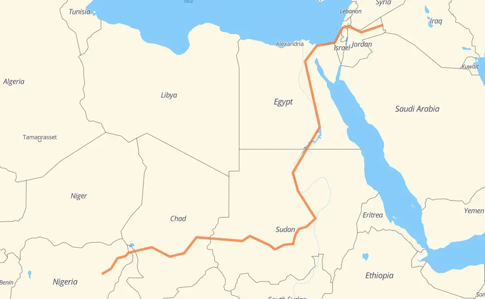
The distance from Tirbil to Bangalori is 3,718 miles by road including 288 miles on motorways. Road takes approximately 70 hours and 41 minutes and goes through Irbid, Afula, Rishon LeZion, Ashdod, Ashkelon, Al Arish and Al Ismailiya.
You can adjust fuel consumption and fuel price here.
How long is a car ride from Tirbil to Bangalori?
Driving time:
70 h 41 min
This time is calculated for driving at the maximum permitted speed, taking into account traffic rules restrictions.
45 mi with a maximum speed 68 mph = 39 min
188 mi with a maximum speed 62 mph = 3 h 1 min
1,677 mi with a maximum speed 56 mph = 29 h 56 min
41 mi with a maximum speed 56 mph = 43 min
1,755 mi with a maximum speed 50 mph = 35 h 18 min
32 mi with a maximum speed 31 mph = 1 h
The calculated driving time does not take into account intermediate stops and traffic jams.
How far is Tirbil to Bangalori by land?
The distance between Tirbil and Bangalori is 3,718.3 mi by road including 287.7 mi on motorways.
Precise satellite coordinates of highways were used for this calculation. The start and finish points are the centers of Tirbil and Bangalori respectively.
How far is Tirbil to Bangalori by plane?
The shortest distance (air line, as the crow flies) between Tirbil and Bangalori is 2,333.9 mi.
This distance is calculated using the Haversine formula as a great-circle distance between two points on the surface of a sphere. The start and finish points are the centers of Tirbil and Bangalori respectively. Actual distance between airports may be different.
How many hours is Tirbil from Bangalori by plane?
Boeing 737 airliner needs 4 h 41 min to cover the distance of 2,334 mi at a cruising speed of 497 mph.
Small plane "Cessna 172" needs 17 h 4 min to flight this distance at average speed of 136 mph.
This time is approximate and do not take into account takeoff and landing times, airport location and other real world factors.
How long is a helicopter ride from Tirbil to Bangalori?
Fast helicopter "Eurocopter AS350" or "Hughes OH-6 Cayuse" need 15 h 39 min to cover the distance of 2,334 mi at a cruising speed of 149 mph.
Popular "Robinson R44" needs 17 h 53 min to flight this distance at average speed of 130 mph.
This time is approximate and do not take into account takeoff and landing times, aerodrome location and other real world factors.
What city is halfway between Tirbil and Bangalori?
The halfway point between Tirbil and Bangalori is el-Multaga. It is located about 140 mi from the exact midpoint by road.
The distance from el-Multaga to Tirbil is 1,719 mi and driving will take about 31 h 26 min. The road between el-Multaga and Bangalori has length 1,999 mi and will take approximately 39 h 15 min.
The other cities located close to halfway point:
Bara,Barah,Bāra,Bārah is in 2,056 mi from Tirbil and 1,662 mi from Bangalori
Al Dabbah is in 1,637 mi from Tirbil and 2,082 mi from Bangalori
Al-Ubayyid is in 2,097 mi from Tirbil and 1,621 mi from Bangalori
Where is Tirbil in relation to Bangalori?
Tirbil is located 2,334 mi north-east of Bangalori.
Tirbil has geographic coordinates: latitude 32.74736, longitude 39.02004.
Bangalori has geographic coordinates: latitude 10.31366, longitude 11.59299.
Which highway goes from Tirbil to Bangalori?
The route from Tirbil to Bangalori follows 25, 10, A4, A3, 35, أ 5.